Water pollution in The Mekong Delta: sources, present, future, ecological impacts and mitigation water pollution in The Mekong Delta: sources, present, future, ecological impacts and mitigation
- THUrsday - 30/11/2017 22:04
- |Close page
Le Trinh, Institute for Environmental Science and Development (VESDEC),
prepared for the International Water Forum, Chungnam, Korea, 17 - 20th 2017
Abstract
The Mekong River Delta (MD) with an area of 40,548 km2 and a population of over 17.5 mil inhabitants, is the main food production region of Vietnam. In the MD there many big rivers and hundreds creeks and canals, creating favourable conditions for growth of biological resource, agriculture, fishery, waterway transport and human activities. However, this region is facing and will be challenged by the increased water pollution caused by the natural factors: high water flow in the rainy season, low flow and high salinity intrusion in the dry season; high acidity at acid sulfate soils areas and by human activities in water use, hydroelectric, industry, agriculture, aquaculture, waterway transport development from the upstream countries and in the Delta, changed hydrological regime and created great amount of many types of wastes, polluting the water environment and damaging ecological resource.
The Mekong River Delta (MD) with an area of 40,548 km2 and a population of over 17.5 mil inhabitants, is the main food production region of Vietnam. In the MD there many big rivers and hundreds creeks and canals, creating favourable conditions for growth of biological resource, agriculture, fishery, waterway transport and human activities. However, this region is facing and will be challenged by the increased water pollution caused by the natural factors: high water flow in the rainy season, low flow and high salinity intrusion in the dry season; high acidity at acid sulfate soils areas and by human activities in water use, hydroelectric, industry, agriculture, aquaculture, waterway transport development from the upstream countries and in the Delta, changed hydrological regime and created great amount of many types of wastes, polluting the water environment and damaging ecological resource.
This paper summarizes the pollution sources, present state ot water quality in the main rivers and canals; impacts of water pollution on aquatic ecology in the MD. At present, the main rivers are slightly polluted but almost all small rivers, canals and some sections of the main rivers are evidently polutted by organic matters, nutrients and bacteria, which impacted on the aquatic organisms and aquaculture. In the rivers, no pollution by toxic pollutants (heavy metals, pesticides) occured. With the increased consequences of upstream activities and rapid economic development in the MD combining with climate change in the coming decades river water quality in the MD would be more degraded. To properly control water pollution and improve water quality in the MD this paper suggestes various international and national actions to be considered by Vietnam, the riverine countries and international organizations.
Key words: Mekong Delta, Water Quality, Water Quality Monitoring, Pollution Sources, Ecological Impact; Climate Change.
Key words: Mekong Delta, Water Quality, Water Quality Monitoring, Pollution Sources, Ecological Impact; Climate Change.
1. Introduction about The Mekong Delta of Vietnam
The Mekong is a trán-boundary river in South-East Asia. It is the World's 10th longest river. Its estimated length is 4,800 km, and it drains an area of 795,000 km2[1], annually discharging 475 km3 of water. Originated from Tibet – Xinghai plateaus the river runs through Yunnan province of China, Myanmar, Laos, Thailand, Cambodia and Vietnam (Figure 1, left).
The Mekong Delta – MD ( Vietnamese: Đồng bằng Sông Cửu Long - "Nine Dragon River Delta" also known as the South-Western Region (Vietnamese: Vùng Tây Nam Bộ) is the region in Southern Vietnam where the Mekong River approaches and empties into the East Sea through a network of distributaries (Figure 1, right). The MD Region encompasses a large of over 40,548 km2. The region comprises 13 provinces, included Cantho City, with the total population of over 17.5 million inhabitants (about 19% of the total population of Vietnam) [2].
The MD is the largest wetland area of Vietnam, where there are 5 national parks, 2 biosphere reserves, 4 nature reserves and 3 species conservation sites at the inland wetland and costal wetland areas with rich biological resources and biodiversity. In the Delta there are 23 mammal species, 386 bird species, 6 amphibian species species and 260 fish species [3]. Fish is one of the main food sources for people in the Delta as well as for the Country.
The MD is the main agricultural region of Vietnam. In the recent years, it supplies more than 56 % of rice, 65% of fish, 75% of fruits for the country and contributes 90% of the total rice export of Vietnam. The annual GDP growth rate of the MD was over 7.0%. In the case of no serious change of natural resources the MD may produce foods meeting the demand of 120 – 150 mil inhabitants. However, this region is still poor, comparing with other regions of Vietnam: in 2015 its GDP/capita was only USD1,850, while the average of Vietnam was USD2,215 [2].
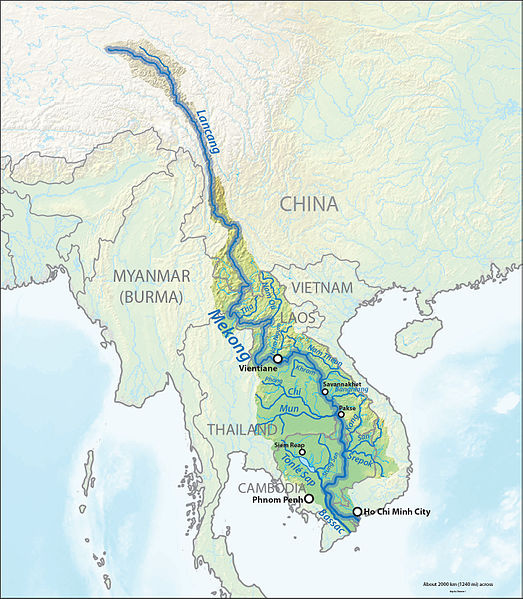

Figure 1: Left: The Mekong River Basin Right: The Mekong Delta in Vietnam


Figure 2: Left: The main stream of the Mekong River in Tiengiang Province Right: There are over 7,500 km of creeks and canals in the Mekong Delta (photos from Internet).
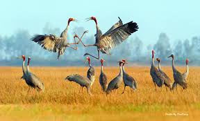

Cranes Grus antigone sharpii in Tramchim Natural Park (Inland wetland zone) Birds in a coastal mangrove forest (coastal wetland zone)


A gigant catfish catched in the Delta river Monkey in mangrove forest of Camau National Park
Figure 3: Some photos about biological resource of the Mekong Delta (photos from Internet).
The Mekong River and its tributaries are the main water resource in the Delta for irrigation, fishing, aquaculture, domestic use, tourism, biodiversity conservation and waterway transport etc. The entire population of the MD now depends and will continue to depend on this resource for its livelihood. With the rapid increased urbanization, industrialization, increased impacts from trans-boundary sources, especially with the increased impacts of climate change, the region is facing more and more severe water environmental problems. They are flooding in the rainy season, shortage in fresh water and increased salinization in the dry season; increased water pollution by domestic, industrial, agriculture, aquaculture and waterway transport wastes. These environmental matters are and will be serious impact sources to water quality and water use in the MD. Therefore, protection of water resource, especially, water quality is utmost important task of Vietnam Government and people in the MD.
2. Factors affecting the water quality in The Mekong Delta
2. Factors affecting the water quality in The Mekong Delta
2.1. Natural Factors
Hydrological Regime
From Cambodia the Mekong flows to the MD by 2 branches: the Mekong (Tien river) and the Bassac (the Hau river). These 2 rivers discharge water into the East Sea through 8 (but not 9) branches. In the MD there are also very dense river and canal network with over 7,500km, and 36,000 km of irrigation canals, dredged by Vietnamese in the recent 300 years for irrigation, drainage and transport.
Greatly depending on rainfall in the basin, the Mekong river’ seasonal flows are quite variable from month to month. Discharge of the Mekong river in the Delta in the rainy season, lasting from May to November may get up over 37,000 m3/s (in September) but it is only 2,220 m3/s in the driest month (March) [1]. With this hydrological regime, in the flooding season inundation occurs at large area and water contain high suspended solids, but low salinity, acidity and and organic, nutrient, hazardous pollutants. In the dry season, especially in March and April shortage in freshwater at many places in the MD and increased water salinity at the coastal area commonly occur. In this season, water pollution caused by domestic, industrial and agriculture wastes is increased.
Climate
The Mekong Delta has an average rainfall of approximately 1,800 mm, but with an uneven distribution both in space and time. The Western region has the most rainfall with annual average from 2,000-2,400 mm, while the East has from 1,600-1,800 mm rainfall on average [4]. The central plains stretching from Chaudoc - Cantho to Travinh - Gocong have the lowest rainfall, with averages of 1,200-1,600 mm. The amount of rain is very unevenly distributed over the year. Approximately over 85% of annual rainfall is concentrated in the rainy months. Rainfall in the dry season accounts for only under 15%, with months January to March having almost no rain, making severe drought at various districts. In the rainy season, occasionally, there is continuous rain, which may last for 3-5 days, with a large amount of rainfall, causing flooding, increase of water levels and reduction of water salinity. In the first months of the rainy season (May, June) storm water may bring great amount of acidic materials from acid sulfate soil areas and organic matters, nutrients, bacteria and other pollutants causing heavy pollution for receiving water sources.
Soil Properties
At present, acid sulfate soils occupy over 1,6 mil ha (or 40% of the total natural area of the MD) (Figure 4). With high content of pyrite (FeS2) under contacting with sunlight and water, acidification can be formed, causing high acidity (low pH), high contents of Fe, Al for receiving water sources. At various small rivers and canals in provinces of Dongthap, Kiengiang, Angiang and Longan values of pH are only 4.5 – 5.5, concentrations of Fe, Al may be over 2.0 mg/L and 0.5 mg/L, respectively. This polluted water may last 3-6 months affecting growth of aquatic animals, damaging fish, shrimps, rice, vegetables and affecting water supply for irrigation and domestic use


Figure 4: Left: Soil map of the Mekong Delta (pink color is area of acid sulfate soils); Right: Acid sulfate soil and canal receiving storm water (photos from Internet).
In the MD 790,000 ha of saline soils (blue color in Figure 4) and about 2.0 mil. ha of land affected by salinity from the East and West Seas. Saline and brackish water may be well used for saline aquaculture and growth of mangrove forests, but water salinization may cause great constraints for water supply for rice, fruit, vegetable cultivation, fresh aquaculture and domestic use. With influence of sea water, especially in the dry season, salinity intrusion is strong at the coastal area of the MD (Figure 5).

Figure 5. Present salinity intrusion in the Mekong Delta (from: Institute of Meteorology, Hydrology & Environment)
2.2. Human Factors
Agriculture Impact Sources
Agriculture, included cultivation, aquaculture and animal husbandry is the important economy for over 70% of the population in the MD. However, at present agriculture is the highest pollution source for the rivers and canals in the MD because of its wastes.
(i) With area of rice, vegetable and fruit cultivation of over 2.5 million ha, annually farmers use about 750,000 – 1,000,000 tons of fertilizes (N, P2O5 and K - Pham Sy Tan, 2012 [5]). Residues of N and P from fertilizers may cause nutrient pollution for canals and rivers.
(ii) According to a VESDEC study for Vinhlong Province (2016) average amount of pesticides used is 3.5 kg/ha for vegetable, 7.5 kg/ha for rice; 15 kg/ha for fruit (mango) cultivation [6], which is still lower than Japan (14.30 kg/ha) and South Korea (10.70 kg/ha) but 2-3 times higher than in the Red River Delta (Vietnam) and much higher than other developing countries like the Philippines (1.56 kg./ha) or Bengladesh (1.50 kg /ha) (UNEP 2005). Total amount of pesticides used may be 10,000 to 20,000 tons/year, included 97 trade marks of 20 chemical groups: conazole, pyrethroids, carbamates, buprofezin, organophosphates, chlorinated phenoxyacetic acids, amides …(Pham Van Toan, Cantho University, 2015 [7]). After use a large part of pesticide containing bags are disposed into the fields, gardens or canals. Pesticide containing bags occupy about 1.0 – 1,8 % of the weight of pesticide and bag. Therefore, annually, about 120 – 360 tons of used bags may be released into the environment in the MD. Residue pesticides and pesticide containing bags are sources of water pollution and ecological impacts.
(iii) At present, in the MD area of aquaculture is 685,800 ha producing over 2.2 mil tons of shrimps and fish (Pangasius and other fish species). According to information from MONRE annually, an amount of 456.6 mil m3 of sediments and wastes is discharged from aquaculture farms [8]. This type of wastes contain high acidic or saline materials, organic matters, nutrients, bacteria, pathogens, which may serious pollute water of the receiving water sources and damage aquatic animals.
(iv) Animal husbandry is also well developed with over 2.6 mil pigs, 260,000 cattles and 40 million ducks. Daily, an amount of 22,500 tons of solid wastes and 40,000 m3 of wastewaters is discharged from animal cages to the environment. Annually, the environment in the MD receives about 432.9 tons BOD, 1,6438 tons COD, 31,700 tons N and 14,800 tons P [9] and high amount of bacteria and pathogens. Therefore, animal husbandry is the great organic, nutrient and bacteria pollution source for rivers and canals.
Industrial Impact Sources
Although in the Mekong Delta industry is less developed but at present in this Region 120 industrial parks and clusters with 25,000 ha have been planned, of which thousands of factories are under operation. According to MONRE [8]: annually, 220,000 tons of solid wastes and 47,000 m3 wastewaters are discharged from industrial parks while only 44% of the industrial parks installed centralized wastewater treatment plants. Industrial wastes are new pollution sources and they may cause serious ecological impacts for rivers and canals in the MD. They may be increased in amount and hazardous composition in the coming decades.


Figure 6: Industrial park on the Mekong river in Tiengiang Province (left) Paper Mill (Lee & Man, Taiwan) on the Hau river in Haugiang Province are pollution sources for the MD water environment. The second has obtained many complaints from people (photos from internet).
Population Impacts
At present, over 17,5 million inhabitants in the MD, of which over 70% are in rural areas. Traditionally, to use rivers and canals as main source for drinking water, fishery, aquaculture, transport and prevention of inundation for hundreds year until now the residents in this region like to settle along the canal banks (Figure 7). With this living way, almost all domestic wastewater and solid waste are directly discharged into canals.
At present, over 17,5 million inhabitants in the MD, of which over 70% are in rural areas. Traditionally, to use rivers and canals as main source for drinking water, fishery, aquaculture, transport and prevention of inundation for hundreds year until now the residents in this region like to settle along the canal banks (Figure 7). With this living way, almost all domestic wastewater and solid waste are directly discharged into canals.
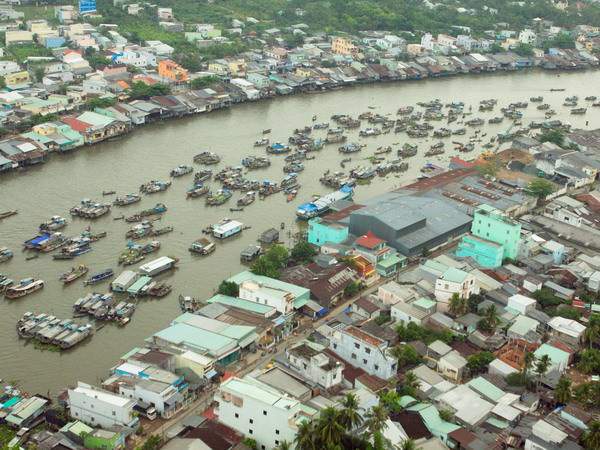
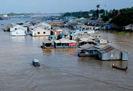
Figure 7: Settlement along river/canal banks (right) and cage fish culture on rivers (left) are sources of water pollution (photos from internet).
In urban areas, annually, 102 mil m3 municipal wastewater, 606,000 tons of solid wastes, included 4,000 tons medical wastes are generated, of which over 85% of solid wastes, 100% of medical wastes are collected and treated but only 30% of effluents are treated [8]. Therefore, wastes generated by local residents are great pollution source for rivers and canals in the MD.
3. Present water quality in The Mekong Delta
3. Present water quality in The Mekong Delta
With the impacts from the natural factors as well as human activities at present water quality in the MD is degraded. However, levels of water pollution are very differ from the locations on a river and from the main rivers to small rivers or canals. According to the monitoring system of the Mekong River Commision (MRC) and many national study projects at almost monitoring sites at the main rivers (the Tien and Hau rivers) water quality is slightly polluted, but still meeting the conditions for domestic water supply and tourism (Source A2, according to the Vietnam National Technical Regulation for Surface Water Quality QCVN08-MT:2015/BTNMT). But at some monitoring sites at the main rivers and at all small rivers and canals where receive wastewater or run-off water from urban, industrial or aquaculture sites water pollution is evident. The main types of pollution are: organic pollution, nutrient pollution, oil pollution, acidic pollution and bacteria pollution. Pollution by toxic chemicals as heavy metals or pesticides is not detected in all monitoring sites on rivers but it is found in some special cases where water directly receive effluents from the factory or field newly treated by pesticides. Some data on the present water quality at the main rivers and small canals in various provinces are given below for demonstration.
3.1. Data of Water Quality Monitoring of Angiang DONRE
Report of Department of Natural Resources and Environment (DONRE) of Angiang Province on the results of water monitoring in July 2017 [10] indicated:
(i) Tien (Mekong) River:
At Tanchau, at the border with Cambodia: TSS, BOD5, COD, P-PO43-, Coliforms exceed at 1.5 – 9.6 (by each parameter) the permissible for the A2 Source (water used for domestic supply) in QCVN 08-MT:2015/BTNMT.
(ii) Hau (Bassac River):
- At Long Binh (border with Cambodia): evident pollution: TSS, BOD5, COD, P-PO43-, Coliforms exceed at 1,7 – 18,4 times (by each parameter) the permissible for the A2 Source in QCVN 08-MT:2015/BTNMT.
Above data show that at present water of the main rivers transported from Cambodia is evedently polluted.
- At Longxuyen City: TSS, COD, P-PO43-, BOD5, Coliforms exceed at 2,0 – 9,6 times (by each parameter) the permissible for the A2 Source in QCVN 08-MT:2015/BTNMT. The data show that pollution of the Hau river at this city is less than that at the border with Cambodia.
3.2. Data of Water Quality Monitoring of Vinhlong DONRE
According to information of Vinhlong DONRE[11]: in June 2017 at all monitoring sites on the Mekong River and small rivers: water was slightly polluted. However, values of pH, BOD5, COD, Fe and Cl- met the permissible limits for Source A2 in QCVN 08-MT: 2015/BTNMT. Comparing with the monitoring data in June 2016: values of TSS, turbidity, BOD5, COD, phosphate, Fe and Cl- are slightly increased.
3.3. Data of Water Quality Monitoring of Tiengiang DONRE
In the project of “Environmental planning for Tiengiang Province…”[12] VESDEC has conducted sampling and analyzing water quality at 20 monitoring sites on the main rivers and various canals/creeks in he whole province in the dry season (March) and rainy season (Auguts) 2013. From the monitoring results some findings may be given below.:
(i) Organic Pollution:
- DO in the Tien river was higher than 5.0 mg/L (Sites NM2, NM5 and NM6) but in small rivers and canals it was low. At 12/20 monitoring sites DO was under 5.0 mg/L.
(i) Organic Pollution:
- DO in the Tien river was higher than 5.0 mg/L (Sites NM2, NM5 and NM6) but in small rivers and canals it was low. At 12/20 monitoring sites DO was under 5.0 mg/L.
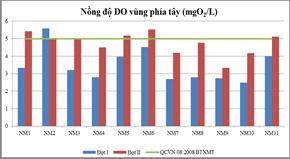

Figure 8: DO (left) and BOD (right) at some monitoring sites in Tiengiang Province (blue: in March, red: in Augiust, 2013)
- BOD values at the monitoring sites at the main rivers and canals were varied from 4 to 10 mg/L, while the permissibnle limit for Source A2 of QCVN 08-MT/2015/BTNMT is 6.0 mg/L. At the main rivers BOD met the standard (5 mg/L) but at almost all canals and some times at the main rivers organic pollution was evident with BOD higher than 6.0 mg/L.
(ii) Nutrient Pollution
Concentrations of ammonium (NH4) at most of the monitoring sites greatly varied from month to month and were higher than the permissible limit for A2 Source, indicating high nutrient pollution at the rivers and canals. With this level of nutrient pollution and in cases of stagnant water eutrofication may be created.


Figure 9: NH4+ (left) and T. Coliform (right) at some monitoring sites in Tiengiang Province (blue: in March, red: in August, 2013)
(iii) Bacteria Pollution
Bacteria pollution was evident at the main rivers and canals but it still met the permissible limit for Source A2 in QCVN 08-MT/2015/BTNMT which is 5,000 MPN/100 mL.
(iv) Pollution by Toxic Chemicals
The monitoring data indicated that at present, water in the main rivers and canals in Tiengiang Province is not polluted by heavy metals, pesticides and other toxic pollutants.
3.4. Monitoring Data at Aquaculture Sites
The monitoring data indicated that at present, water in the main rivers and canals in Tiengiang Province is not polluted by heavy metals, pesticides and other toxic pollutants.
3.4. Monitoring Data at Aquaculture Sites
According to the monitoring of the Fishery Department of Cantho City in July 2017 [13] all parameters of DO, pH, nhiệt độ, COD, PO43-, NO2-, NH4+, S2-, TSS in the Hau (Bassac) River at Thotnot District, and rivers in Omon, Vinhthanh Districts meet the water quality for aquaculture (QCVN 02-20:2014/BNNPTN) and met the permissible limits for Source A1 in QCVN 08-MT:2015/BTNMT and Boyd (1998). However, at some monitored ponds the parameters of NH4+ (0.60 – 1.90 mg/L), PO4 (0.37 – 0.52 mg/L) exceed the permissible limits in QCVN 02-20:2014/BNNPTNT nad Boyd 1998.
3.5. Evidences of Pesticide Pollution
3.5. Evidences of Pesticide Pollution
From 1995, the high persistent and high toxic pesticides like organochlorines and organophosphates were banned in Vietnam, therefore, residues of these compounds are very small. However, some studies indicated their presence in water, soils and animal tissues with very low contents.
A paper of Zita Sebesvari et al. (2012) [14] indicates that in the MD, Minh et al. (2007) reported DDT contents in sediments ranging from 0.01 to 110 ng/g dry weight along the Hau River with the higher contents found near urban areas such as Cantho City. Carvalho et al. (2008) monitored more than 70 pesticide residues and polychlorobyphenyl compounds (PCBs) and found sediment contents of DDT ranging from 0.45 to 67.49 ng /dry g weight and contents in the soft tissues of bivalve molluscs ranging from 5.46 to 123.03 ng/g dry weight. Other organochlorines detected in sediments but at much lower contents were hexacyclochlorohexane (HCHs), endosulfans and chlordane.
A study project conducted by VESDEC for Vinhlong DONRE (2016) [6] indicates that 2/9 soil samples collected near tanks containing pesticide bags content of Lindane is 0.0025 mg/kg dry weight and 0.0045 mg/kg dry weight, which are much lower than the permissible limit in Vietnam National Technical Regulation for Soils (QCVN 15:2008/BTNMT: 0,01 mg/kg dry weight); 5/9 soil samples contain Chlorpyrifos (-ethyl) with 0.015 to 0.055 mg/kg dry weight.
4. Ecological impacts of water pollution
As indicated in Section 3, at present, the main pollution types of the Mekong Rivers and its branches in the MD are organic, nutrient, bacteria pollution. They are caused by untreated domestic, animal husbandry, aquaculture and industrial (food processing, paper and other industries) wastes and run-off water from field treated by fertilizers. Acidic pollution is also common at the acid sulfate soil areas. So far, there are not many researchs on ecological impacts of water pollution in this region. However, from observations by the author and information from newspapers the following evidences may be given for demonstation of damages caused by water pollution on aquatic ecosystems.
(i) With high contents of organic matters dissolved oxygen (DO) is reduced. At DO of under 3.0 mg/L most of shrimp species and various small white fish species (Esomus spp.,Carassius spp.) can’t survive. At DO of under 2.0 mg/L many big white fish species (carp, Hypophthalmichthys spp., Mylopharyngodon spp.) may die. In the MD many massive death of fish were caused by untreated effluents from aquaculture and or industries depleting DO in water.
| a. Massive Fish Death at Cage Fish Farms in Angiang Province On 4rd to 6th February 2016 at the cage fish farms on the Caivung river in Angiang and Dongthap Provinces over 1,000 tons of fish at 119 fish cages die. The main fish species were Oreochromis sp.(điêu hồng, in Vietnamese), Oreochromis sp. (rô phi, in Vietnamese) Barbonymus sp (cá he, in Vietnamese) [15]. Loss due to the massive fish death was estimated as USD 750,000.  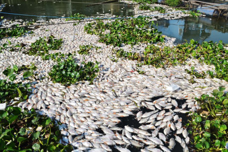 Growth of fish Oreochromis in a fish cage Massive fish death in Caivung river, 6th February 2016 (photos from internet). b. Massive Fish Death in Camau Province According to “Thanhnien Newspaper” [16]: from November 2017 to 24 April 2017 there were massive fish death at Bayhap and Ganhhao rivers in Camau Province. Water in the rivers was grey and rotten. Polluted water from thepolluted rivers discharged to shrim farms caused massive death for shrimps. |
(ii) High concentration of N and P salts in water may create eutrophication of water bodies with a depletion of DO in the water column, algal blooms, increased turbidity, reduction in aquatic animal populations and cause difficulty for water treatment. This phenonmenon is very common in small rivers and canals in the MD: water hyacynth densely growth – an indicator of water eutrofication may be found in all ponds and canals in this region.
Additionally, ammonium (NH4) is a toxic pollutant for shrimp and fish: FAO guides NH4 is lower 0.2 mg/L for Salmonid spp., and 0.8 mg/L for Cyprinid spp.
(iii) At actual acid sulfate soil areas in the beginning of rainy season, storm water brings acidic materials to the rivers and/or ponds. At high acidity (pH under 4.5) all shrimp species and many white fish species may die. At pH lower than 3.5 almost all species of white and black fish can not survive. Massive shrimp death at the shrimp farms caused by acidic water transported from acid sulfate soil area were reported in the MD.
5. Challenges of water quality in The Mekong Delta in the coming decades
5.1. Increased Economic Growth
According to Decree N245/QĐ-TTg 12 Feb./ 2014 of the Governmant on the Master Plan for the Mekong Delta Key Economic Zone, included Cantho, Kiengiang, Angiang and Camau Provinces [17]: in the period 2016 – 2020: the annual growth rate is planned as 10.5 %; in which industrial sector will be 10-12%/year; population growth rate will be under 1.0%/year; ratios of economic sectors will be industry – construction: 37.4%, service: 45.3 %, agriculture – fishery – forestry: 17.3%; GDP/capita: USD4,400 in 2020 and USD9,300 in 2030. In 2020 100% industrial parks and cities will have wastewater treatment plants meeting the environmental standards and 100% urban and industrial solid wastes will be collected and treated.
This tendency of rapid economic growth may cause various impacts on the water environment, particularly on water quality, due to rapid increase of domestic, agriculture, aquaculture and industrial wastes, included hazardous wastes.
5.2. Increased Impacts of Climate Change
Due to very flat and low land and with diurnal tidal regime, the MD is region may get most serious impacts by climate change. Consequences of climate change in the MD are increased drawth in the dry months and increased salinity intrusion from the Seas to inland. At present, climate change evidently affects water resource, it will cause more serious impacts in the coming decades.
According to MONRE [18] in the MD with the average scenario of GHG emission sea level rise in 2050 will be 20 – 30 cm or 57 -73 cm in 2100; with the high scenario of GHG emission sea level rise in 2050 will be 40 – 60 cm and 78 – 95 cm in 2100.
With strong increase of sea levels, salinity will intrude along the rivers into inland area, changing water quality of the rivers from fresh to brackish, affecting water supply for domestic use, for cultivation and freshwater aquaculture.
With strong salinity intrusion, land will be salinized. According to a study of the Water Resource Management Department (MONRE)[19] in the coming 50 years area of land affected by salinity of over 4‰ will be 1,851,200 ha (47% of the total Delta area), increasing at 439,200 ha; area of land affected by salinity of over 1‰ will be 2,524,100 ha (64% of the total Delta area), increasing at 456,100 ha, comparing with that in 1991-2000.
5.3. Increased Impacts from Mekong Upstream Activities
According to the master plans for hydroelectricity and water resource development of the upstream countries over 20 large size projects are under operation and over 130 other projects were planned on the Mekong main stream and its tributaries. Figure 10 shows some of them.

Figure 10. Some projects in dam and hydroelectric development in the Mekong river basin (from: Nation Graphics)
The hydropower and water diversion projects, included dams and reservoirs may strongly reduce the Mekong flow and increase of salinity intrusion into the MD. This will cause strong impacts on water quality: increase of water pollution by wastes; reduction of TSS, turbidity and nutrients affecting cultivation and aquaculture; increase of water salinity etc.
With increased sea level rise by climate change plus reduced upstream discharge by the hydropower, dam projects of China, Lao, Thailand the environment, in general, and water quality in the Mekong Delta will face with many challenges for protection and use.
6. Recommendations of actions for water pollution control and improvement of water quality for The Mekong Delta
Water quality of the rivers, creeks and canals in the MD greatly depends on water flow from the upstream area, rainfall, soil properties, salinity intrucsion from the Seas and from human activities in the region and upstream countries. Therefore, to properly prevent water pollution for the Mekong Delta integration of internal and external actions is necessary. Because of limitation of a paper, the following suggestions give only the tittles of the important actions without explanations.
6.1. External Actions – International Cooperation
The following external actions are suggested:
(i) Improvement of the MRC in its functions, manpower, financial and technical sources to have suitable capacity in management of water resource, environmental and social assessment of the policies, plans, projects related with the basin development and in coordination with all upstream, downstream countries and international organizations in sustainable use and protection of the Mekong river.
(ii) Increase of participation of international organizations (UN and its organizations: UNDP, UNESCO, FAO, WHO; WB, ADB) and countries outside the Mekong basin (US, Japan, Korea, India etc. into protection of water resource, ecology and water quality in the Mekong basin.
(iii) Careful implementation of EIA/ESIA for the proposed projects in water resource, dam, hydroelectric development in the Mekong river basin with participation of international and riverine country organizations, experts and with targets of protection the aquatic ecology, water resource and sustainable development in the basin.
(iv) Improvement of water quality monitoring programs of the MRC.
(v) Improvement of waste management of the riverine countries.
6.2. Internal Actions: Water Pollution Control in the Mekong Delta
General Actions
(i) Increase of awareness on water resource, impacts of water pollution and protection of water quality for local communities, especially, for farmers in waste management in cultivation and aquaculture and for all people in management of wastes.
(ii) Strictly implement the Law of Water Resource, Environmental Protection Law, Law on Biodiversity and the National Technical Regulations (Standards) for Surface Water Quality, for Industrial Effluents; for Domestic Wastewater.
(iii) Strictly implement the target of the Master Plan for the Key Economic Zone of the MD: by 2030: 100% of industrial parks and all cities should have wastewater treatment plants meeting the environmental standards.
(iv) Ministries of Natural Resource and Environment (MONRE) and Agriculture and Rural Development (MARD) and Provincial DONREs and DARDs must stricter implement water quality monitoring, supervision on wastewater discharge and punishment on infrigements in water resource protection.
(v) Development of projects in studies on changes of water quality caused by human activities and natutal factors; water quality monitoning, impacts of climate change on water quality and measures for pollution control in the Mekong Delta.
Specific Actions for Economic Sectors
(i) For Industrial Sector:
- Strictly comply with the national technical regulations for wastewaters: all industrial parks and companies must build and operate wastewater treatment plants to treat wastewaters complying with the National Regulations.
- Rehabilitation and compensation for ecological and social damages caused by water pollution from industrial facilities.
(ii) For Agricultural Sector:
- Development and improvement of integrated pest management (IPM) and other models to reduce use of pesticides and chemical fertilizers.
- Properly control storm water from treated field by agrochemicals and used pesticide containers to avoid impact on quality of receiving rivers.
- Properly control acidic materials released from acid sulfate soil areas.
(iii) For Aquacultural Sector:
Properly control solid and wastewater from shrimp and fish culture farms to avoid impact on quality of receiving rivers.
(iv) For Resetlement Sites:
- Rapidly relocate houses and other constructions on canals and rivers to avoid water pollution.
- Install sanitation facilities complying with the requirements for all houses.
- Cities and towns must build and operate wastewater treatment plants to treat municipal wastewaters complying with the National Regulation.
References
1. Mekong River Commision (2005), Overview of the hydrology of the Mekong Basin.
2. General Statistic Department, Vietnam(2016), Data on socio-economy of the Mekong Delta, 2016
3. Nguyen Xuan Hien (2015), Natural resources in the Mekong Delta, Environmental World (in Vietnamese), 26 Mar.
4. Southern Hydrology &Meteorology Station, Data on climate of the Mekong Delta.
5. Pham Sy Tan (2012), Fertilizer use in the Mekong Delta, Cantho University.
6. VESDEC (2016), Project of Supporting models for safe management of used pesticide containers for Vinhlong Province.
7. Pham Van Toan (2015), The present state of pesticide use in the Mekong Delta, Cantho University.
8. MONRE (2015), Information on pollution control in the Mekong Delta.
9. Duong Van Vien (2015), Pollution in the Mekong Delta.
10. DONRE Angiang Province (2017), Report on water pollution of the Mekong river in Angiang.
11. DONRE Vinhlong Province (2017), Report on water pollution of the Mekong river in Vinhlong.
12. VESDEC (2014), Project of environental planning for Tiengiang Province.
13. Cantho Department of Fishery (2017), Information on water quality at some aquaculture farms.
14. Zita Sebasvari et al. (2012), In book: The Mekong Delta System - Interdisciplinary Analyses of a River Delta, Chapter: Agriculture and Water Quality in the Mekong Delta, Vietnam., Publisher: Springer, Editors: Renaud, F.; Kuenzer.
15. DONRE Angiang Province (2016): Report on massive fish death, Feb.2016
16. Thanhnien Newspaper 26. Jun. 2017, Massive fish death in Camau Province.
17. Decree Decree N245/QĐ-TTg 12 Feb./ 2014 of the Governmant on the Master Plan for the Focus Mekong Delta Economic Zone, included Cantho, Kiengiang, Angiang and Camau.
18. MONRE (2012), Scenios of sea level rise in Vietnam.
Note: The above article reprinted at the website or other media sources not specify the source http://vesdec.com.vn is copyright infringement